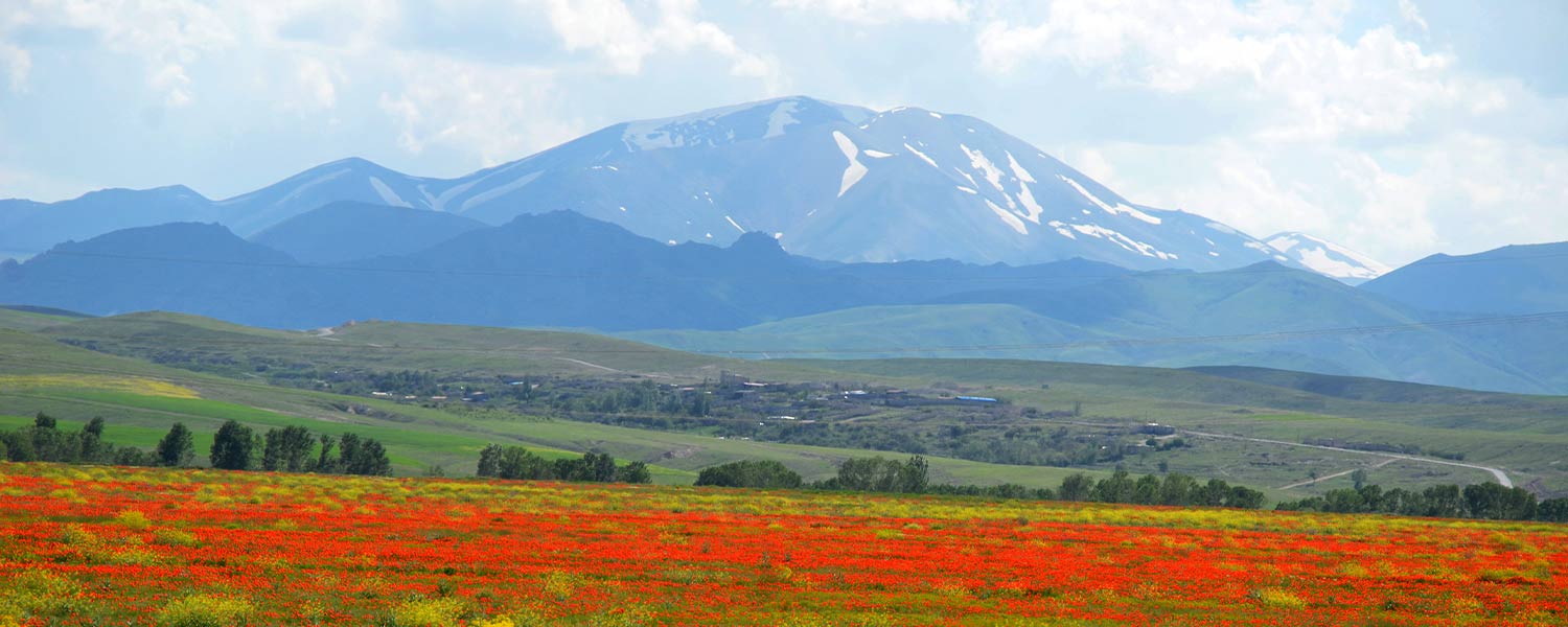
Sahand Peak; Flower-covered peaks
Sahand Peak; Flower-covered peaks
Sahand is a volcano and mountain range in the Azerbaijan’s mountains, which is located 50 km south of Tabriz, west of Bostan Abad, 40 km north of Maragheh and Hashtrood, east of Azarshahr, Ajabshir and Osku and in the center of East Azerbaijan province. Sahand mountain range has 17 peaks with a height of more than 3,000 meters, the highest one is Kamal peak, the height of the peak is 3,711 meters and it is the highest point of East Azerbaijan province. Although Sahand and other peaks of this region haven’t a place in the table of the highest peaks in Iran, but this mountain is famous for its beauty and special geographical location. These snow-capped peaks are located in a part of the center of the Azerbaijani plateau, which are too important for rural and nomadic life.
19 permanent rivers and 4 seasonal rivers originate from this mountain. Part of the water of these rivers enters the Caspian Sea through Qaranqo valley and Ghezel Ozan river and part of the waters of this mountain flows towards Urmia lake. Sahand Peak is covered by snow most of the year and a small lake that is specific to these mountains can be seen on its slopes.
Sahand volcano activity
Sahand volcanic material has covered an area of approximately 4,500 square kilometers on various sediments. This area doesn’t include the thin layer of Sahand volcanic ash in remote areas (for example, around the Bostan Abad-Tabriz road). Determining the absolute age of Sahand lavas has shown between 0.14 million to 12 million years. Thus, Sahand volcano has been actived in several stages and relative calm has been established between these active stages.
Sahand is an outbound igneous mass that is located as a cap on a base of sedimentary rocks of different ages. The thickness of the volcanic material is estimated to be more than 800 meters. Therefore, according to the above, Sahand can be considered a classic type of a stratified volcano.
Routes to climb Sahand peak
Sahand has several fronts, the peak on the left (west) has a height of about 3,528 meters and Jam peak on the right (east) is about 3,548 meters high.
From Sahand and Jam peaks, in clear weather, you can see Qūch Golī Dāghī and Kamal peaks and hot peaks in the north. First route to climb Sahand, is Qeyrokh Bolaq and it takes 3 to 4 hours of mountaineering to the top of the peak. This route will be very beautiful and diverse for climbers who want to use more of their leisure time. The origin of the climb in this route is the village of Isparaxan at an altitude of 2, 400 meters. This village is located on the northern slopes of Sahandabad Rural District and dirt roads with a length of approximately 35 km connect it to Tabriz.
The next route is in the south direction and along the Basmanj Chai river and in the opposite direction, along the route, the river will be on our left.
Continuing the route, after 2 to 3 hours, we will reach a place called Abgarm. This place has a dome-shaped building and at a depth of two meters there is a pool of mineral spa and if desired, it will be the best place for camping.
We continue the way until we reach the end of the main valley and after 90 degrees turn to the east (left) and after continuing the mountaineering to the right, we will reach a pass.
To the south of this pass is another pass, and the route, after traversing a side valley, will take us to the second pass, which is about 3,100 meters high.
The distance from the second pass to the top of the peak will be about 3 to 4 hours. This way, you will have an average of 14 to 15 hours of mountaineering the entire route.
How to reach the origin of climbing Sahand peak?
To reach the origin of this route, from the Tehran-Tabriz freeway toll, after a distance of about 60 km on the transit road, we reach Bostanabad. From Bostanabad, we take our local minibuses to the village of Chichakloo at an altitude of 2,500 meters. From Bostanabad, we will pass through the village of Pishkloo, finally we will reach Chichakloo. The distance from Tabriz to Bostanabad is about one hour and the dirt road from Bostanabad to Chichakloo village is about 2 hours. From Chichakloo the mountaineering route will continue to the west and towards the gorge, which is about 3,000 meters high, until after about 1 to 2 hours, we will reach the gorge and we will see Sahand peak in the southwest direction.
Flora and fauna of Sahand peak
156 plant species have been identified in Sahand Protected Area, 26 of which are endemic. Types of plants in the highlands include: Astragalus, Siahgeon, types of hill plant plants including Astragalus and Ferfion are scattered in the northeastern slopes of the region. Extreme cold during the winter and heavy snow in this mountain have prevented the growth of trees and shrubs, but different plant genera, all of which are herbaceous and annual, can be found in abundance in the pastures and meadows of Sahand.
Significant species of Sahand Protected Area including mammals including Armenian ram, Lynx, Brown bear, Leopard, Wild cat, Mink, Wolf and Fox, several species of Bat and there are different types of Rodents in the area. Birds belong to the order of Falcons and Golden eagle and vulture.
Sahand range and its plains have become an important habitat for wildlife and seeing each of these landscapes is interesting and memorable for tourists.
The best time to climb Sahand peak
Sahand mountain has a cold climate. Rainfall in this area is between 300 to 600 mm per year. In terms of climatic division, this region is among the regions with an altitude of more than 2,000 meters. The presence of mild summers and cold and long winters are the characteristics of these areas. Due to the climatic conditions of this region, IMT recommend to climb Sahand and Jam peaks is in May and June.