Taftan Mountain; a semi-active volcano in Iran
Taftan Mountain; a semi-active volcano in Iran
Taftan Mountain; The only semi-active volcano in Iran
Taftan peak is the highest peak of Sistan and Baluchestan province with about 3,941 meters height, which is located in the volcanic mountains. Khash is the closest city to Taftan Mountain. The diversity of climate, vegetation and abundant water in this mountain is a symbol of the unique and masterpiece nature of this region. IMT invites you to read about this magnificent volcano peak.
Taftan volcano activity
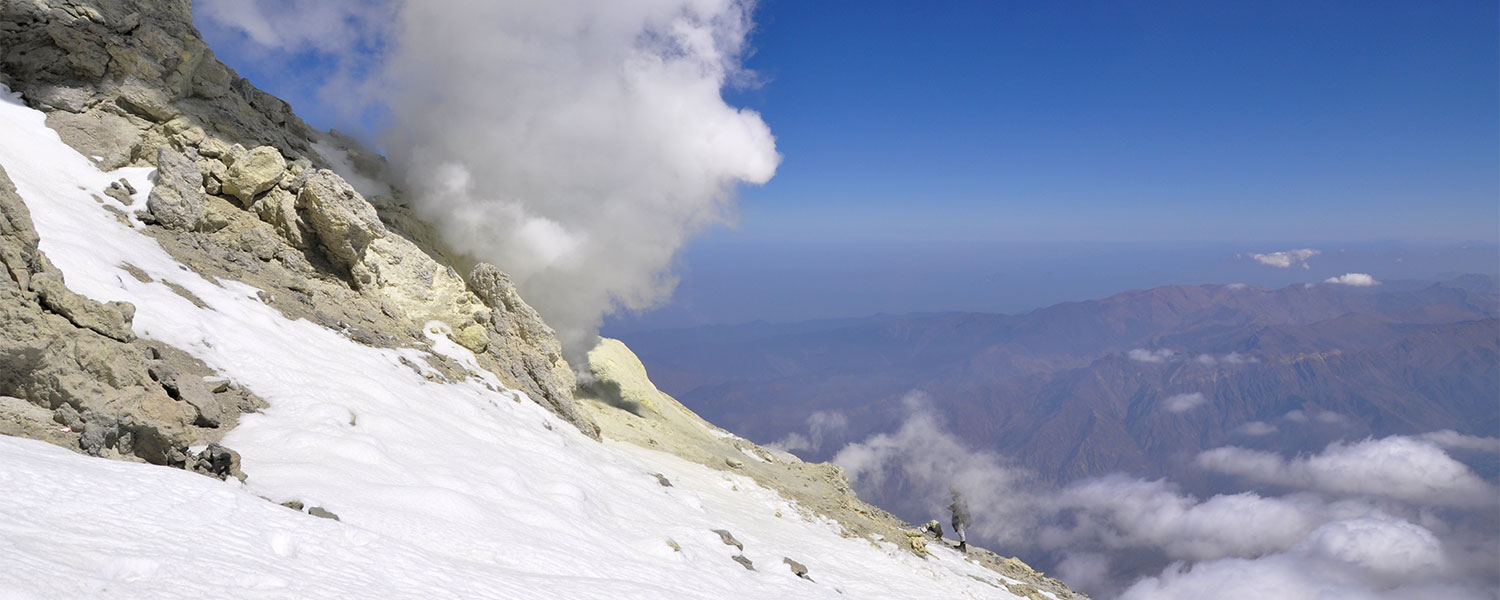
There is a steep crater on the southern slope of the volcano, part of which has been damaged by a severe eruption and subsequent erosion. Taftan's first volcanic eruption was twenty kilometers northwest of the current peak, and then other centers to the east of this point have been activated. The activity of these centers is in the form of explosive eruptions and the result is dacite and agglomerate rocks sections. The first activity to form the present-day shape of the northwestern cone must have been before the Pleistocene. Taftan is a stratified volcano that seems to have more historical complexity than Damavand.
Routes to climb Taftan Mountain
There are 4 ways to climb Taftan:
- Shelter route on the western front
- Torshab village from the east
- Tamin village in the north
- Sangan intersection and Khanjak village in the northeast
The busiest route that climbers choose and where there is a shelter is the route of the western front.
But the southwest route is the most common climbing route for climbers too, in the middle of the road there is a shelter called “Sobah”. To reach the origin of the climb, climbers must reach a village called Darreh Gol on the western slope of Taftan, this village is located near the city of Khash and its road is asphalt but of low quality. It is noteworthy that the village is located 170 km from Zahedan. The height of Darreh Gol village is 2,500 meters above sea level. There is also a campground and a building for overnight accommodation for tourists and climbers. It is also possible to rent a house from the villagers for the night. From here, the ascent route goes up along the water stream that flows in the mud valley to reach the source of the water. The main water flowing in this valley is non-potable, but there is a spring in the middle of the path called good water!
From here, the path to the rift of a valley called Tang-e-Gelu will be accompanied by ups and downs of boulders. Also, in the middle of the road, some arrows and memorabilia can be seen along the way. After crossing the gorge, the route continues through a narrow sandy valley to reach a relatively flat area. In the continuation of the route, by climbing from the left edge, the big shelter of Taftan can be seen. The shelter of Taftan Mountain called Sobah is located at an altitude of 3,250 meters. Below the shelter of Taftan Mountain, there is a small spring from the spa to sulfur deposits. The shelter has two water sources in which fresh water is stored. The route from the top of the shelter to the summit is marked as a small ridge. Below the summit and on the volcanic boulders, this ridge also disappears. Here, by climbing from the left to the top of the boulders, the route continues from a relatively flat area to the peak of Taftan, where the release of sulfur gas is known, and finally you will reach the peak of Taftan.
Flora and fauna of Taftan mountain
Plants that can grow in this area include trees such as Pistachios, Almonds, Turmeric, Artichokes and vegetation such as Thyme, Warmth, Chicory, Rhubarb, Yarrow, mint and Astragalus. The animal diversity of the area Foxes, Jackals and Wolves are part of the animal cover of the area.
Special features of Taftan peak
- As mentioned, this mountain with 4 peaks and 3 volcanic craters is on the list of volcanic mountains.
- Taftan is part of a volcanic mountain range called Khamush Sultan that extends to northern Pakistan.
- Another attraction of Taftan is the existence of two wallsو which are considered as the destinations of climbers. Also, in the heights of Taftan, there are 3 lakes called Daryasar and Ladiz and Gazd rivers. There is also a sulfur hot spring and a sweet hot spring in this mountain.
Access route to Taftan peak
The best way to go to Taftan Mountain is through the city of Khash, 20 km north of Khash towards Zahedan, you can see the access sign to Taftan Mountain. If you go to Khash from the north of Sistan and Baluchestan, you will reach this exit route at a distance of 130 km from the south of Zahedan city. On this side road you have to drive about 30 km to the east.
Along the way to reach Taftan Peak, you can also visit the beautiful villages of this region.
The best season to climb Taftan
Taftan isn’t generally snow-capped, but it has cold winters and autumns with strong winds; So, the 3-hour journey to the shelter takes 8 hours. It also has relatively cold nights in spring, but again, the best time to climb is April to early May.
IMT doesn’t recommend to travel to the peak in summer because it will be difficult to climb due to the extreme heat.
What should we take with us to climb Taftan Peak?
Taftan is not a snow-capped peak in all seasons, but if you plan to climb this peak in autumn and winter, be sure to take different layers of clothing with you to deal with cold winds.
If you go to this mountain in spring, the temperature will be low at night.
You can use a scarf or shawl to close your mouth and nose so that the sulfur gases do not bother you. Glasses, sunglasses and sunscreen are also essential for mountaineering. Due to the fact that your clothes smell of sulfur (smells like rotten eggs), it is recommended to have extra clothes with you.